A 5.5 mile to the summit of Pumlumon Fawr, Cereidigion, Wales
As it was quite blustry there is limited drone footage Enjoy the walk.
Walk Description
This is a 5.5 mile walk that starts at Eisteddfa Gurig on the side of
the A44, in Ceridigion, Wales. This is a very good walk to do after wet
weather as much of it is on stone tracks. As it is easily accessible from
the main road and there is not a huge amount of ascent it is also suitable
for families with young, active children.
You can see the Ordnance Survey map
here
Either park at the farm where there is a parking charge or find the
lay-by about 800 metres east of the farm and walk back up the road; watch
out for traffic though it is busy. The latter will take you past the
rather strange 'Elvis
Rock' as well.
After parking head for the farm yard entrance then
turn right between the farm buildings, you will probably be met by some
barking dogs in a shed. Continue through the other side and go straight
ahead towards a gate ignoring the track on the left over a cattle grid
(you will return that way). Then just follow the track as it winds up with
a stream on the right hand side. Eventually the incline levels out a bit
and after about a mile and a quarter you will see some old mine workings
on your right. The Cambrian mountains were famous at one time for their
lead and silver mines. There are various old bits of mine equipment around
as well as, no doubt, a few places to injure yourself if you don't take
care exploring.
Look for the footpath sign on the left and then turn off the stone track
and follow the path up to the ridge. At the top there is a ladder style
over the fence to the summit itself with spectacular views and Nant yr
Moch reservoir in front of you. Once you have finished on the summit go
back over the stile and turn right and follow the path down the fence line
which eventually becomes a well defined grass path.
Once you get near the conifer plantation you can see in the distance the
track becomes stone again and after passing a
solitary telecommunications tower it turns east near the plantation and
drops down to some farm sheds in the distance.
Follow it down past the sheds and eventually you will be back at the farm
where you started.
Interesting Facts
The Pumlumon area is the largest watershed in Wales and is the source of the rivers Wye, Severn and Rheidol. Since 2007 the Wildlife Trusts of Wales have been working to improve the habitat as a "living landscape" project. This watershed area has been affected by loss of biodiversity, erosion of the peaty soils' structure, and accelerated drainage. Some believe the drainage issues have contributed significantly to flooding in areas some distance downstream, though this cannot be clearly proved.Like most of the uplands across Wales, intensive land use activities have resulted in many habitats being either lost or degraded. Over-grazing of sheep has induced soil compaction, which has resulted in increased flooding of the lowland areas. The principal land cover within the project area is dominated by a complex mosaic of locally, nationally and internationally important habitats and species, such as dry and wet dwarf-shrub heathland, blanket bog, unimproved acid grassland and a number of oligotrophic lakes. Agriculturally improved grassland, broadleaved woodlands and forestry plantation are also characteristic features of the area.
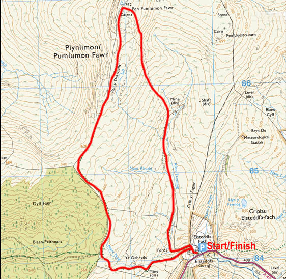
Map
The map below shows you the route of this walk. Bing Maps is a useful resource for Ordnance Survey maps and you can see this and the wider area here
Please ensure that you are properly equipped for the ground conditions
and weather. The information on this site is given in good faith and was
accurate at the time of writing but you are responsible for your own
safety when out walking. We accept no liability for anyone doing anything stupid!