A 13.5 mile walk in the Doethie Valley starting at Llyn Brianne in Ceredigion, Wales
Having had more practice piloting the drone the aerial footage is improving! Enjoy the walk.
Walk Description
This is an 13.5 mile walk that starts at Llyn Brianne, in
Ceredigion, Wales. Llyn Brianne reservoir is shared by 3 counties but
this walk lies in Ceredigion.
You can see the Ordnance Survey map
here
Park in the upper car park at Llyn Brianne reservoir. Go through the gate and cross the spillway following the tarmac track along the boulder edge of the reservoir. Keep
following this track around the reservoir edge.
Eventually you will see the sign board where you enter the Tywi forest; keep going. You route will wind around and pass behind the white cottage that you can see. The cottage 'Dalarwen' is an off grid holiday cottage
should you fancy time away from civilisation!. You will pass behind it on
the track and then keep following the track upwards ignoring any left hand
turns. Eventually the track rises to a point where the woodland is
thinning
out. Take the track to the right to where there is a barrier and cattle
grid leading out of the forest onto a track.
The track then winds downhill in a northerly direction with beautiful
views up the valley. Keep going mostly downhill (over two metal gates that
are usually locked). You are heading for the footpath on the map below
that leads up to Nant Llwyd farm. Strictly speaking the footpath starts
through a metal gate up on a grass bank and cuts across the corner of a
field to the track. We walked to the track itself (signed Private - No
Entry!), turned left and walked up the farm track itself as the footpath
does continue up it after the first 150 yards or so.
Continue up the track, past some modern farm buildings high up on the
right until you come to Nant Llwyd itself. Walk past the front of the
farmhouse itself then take the track on the right immediately after the
farmhouse but before the farm buildings. This track then continues a
steady rise uphill past the farm. Eventually the track swings left (south)
but the footpath continues South West along a field fence. Follow the
fence on the left hand side and after a few hundred yard you will come to
a walking gate into the rougher landscape behind.
Once
through the gate the wonderful spectacle of the Doethie Valley opens up
before you. This is undoubtedly one of the best views in the whole of
Wales. Writer Jim Perrin described the valley as being ' a high contender
for the most beautiful in Wales'. He is correct, it is spectacular and
unknown to most people because it involves some effort getting there. Take
the track that winds down to the river, drinking in the landscape as you
go.
At the bottom, near the river, you will meet the track that follows the
river. Turn left and follow it south following the river downstream. Be
aware that this track can get extremely wet and can remain so even after
long stretches of dry weather. It can also get churned up by the mountain
bikes that sometimes also use it. Follow the track for about 2 miles and
eventually the landscape becomes less rugged. Finally the rough track
joins a more recognisable roadway that leads to a farm; Troed Rhiw
Ruddwen. Pass through the gates by the farmhouse and after the last gate
you will see a track turning uphill (north east) to your left.
Take this track uphill. You still have a last bit of uphill (don't forget
to look back at the views behind from time to time) to do but
eventually after it levels out at the top you will find yourself back at
the track around the reservoir. Turn right here and follow it back to the
dam and where you started several hours ago. The complete walk is around 13.5 miles
and takes about 6 hours. Enjoy!
Interesting Facts
On the 15th May 1973 the Llyn Brianne dam was officially inaugurated by Princess Alexandra.Llyn Brianne is a man-made reservoir in the headwaters of the River Tywi at Rhandirmwyn above Llandovery, constructed to provide water for Swansea and its surrounding area. It is, in essence, a constructed mountain of crushed rock and clay 300 ft high, blocking the valley. It is the tallest dam in the UK and is the world's largest clay core dam. In 1996 a concrete extension was built, which increased the capacity of the reservoir to 14,200 million gallons. It has a hydroelectric plant, with three turbines producing 4.3Mw – enough electricity to power a small town. It is named after a stream called ‘Nant y Bryniau’, misspelt as Brianne.
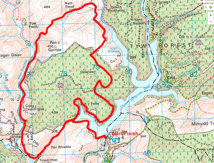
Map
The map below shows you the route of this walk. Bing Maps is a useful resource for Ordnance Survey maps and you can see this and the wider area here
Please ensure that you are properly equipped for the ground conditions
and weather. The information on this site is given in good faith and was
accurate at the time of writing but you are responsible for your own
safety when out walking. We accept no liability for anyone doing anything stupid!